
398th Target: Mannheim
probably early September 1944
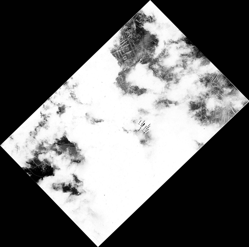
Below is a target photo for Mannheim, Germany along with an analysis of how it was determined to be Mannheim. The photo shows heavy cloud cover and a cluster of eight bombs.
Some of these photos were obtained from the Edward C. Jordan 398th Photo CD.
Information about this photograph:
The Analysis: Scott Welty initially initially analyzed Unknown Target 2, now called 398th Target: Ludwigshafen/Mannheim - probably early September 1944. That photo has many more identifying landmarks, primarily due to less cloud cover and it might be useful to view that target and analysis via the preceding link first before reviewing this one. Both Target Photos 1 and 2 were in Ed Jordan's photo collection. Ed's last mission was on September 3, 1944 to Ludwigshafen, Germany and he flew back to the States on September 22, 1944. Thus his dates in Nuthampstead fortunately limit the timeframe of the photos. Scott had a hunch that this photo was in the Ludwigshafen/Manneheim area also, but the large cloud cover and few distinctive landmarks made it much more difficult to pinpoint it precisely within that area. In an early e-mail, Scott stated: "There is not much visual evidence on this photo since it is mostly either clouds or bomb smoke. Haven't found a match yet, though the combination of river, city and farm land is reminiscent of the Mannheim area both in the other photo and in Google satellite pics." Scott had developed a technique with the Original Target 2 of using Map Quest and Google Satellite Maps to move up and down the Rhein looking for matching characteristics in the photos. On June 2, 2007 he wrote: "There are only three areas on the film where the ground can be seen. Two areas have buildings in them though one of them is mostly farmland, the third area appears to be water." On July 10, 2007, Scott wrote that he had solved the puzzle of the location as Mannheim. The key being a small section of the target map near the top. Scott wrote: "The cropping from Target Photo 1 (see crop photo below) shows the stadium and the buildings forming a rectangle within a rectangle. The inner rectangle turns out to be a courtyard road named Almenplatz. This was the section of the photo that cracked the case. Dave, you're right, I did go after this section like a jigsaw puzzle. Stadiums are confusing by themselves. There are so many of them in Germany. Go to Google and just drag pictures of any German city around and you'll find stadium and soccer fields all over. So I set my eye on three things 1) The stadium, which had to point to: 2) Two fairly long roofs that were parallel to each other. If the two parallel roofs weren't there in that position then it wasn't my stadium. 3) The rectangle within a rectangle buildings had to be about a block away from the parallel roof. I started my search with Mannheim & Ludwigshaven first using not this clue section but the water section. I was convinced (and wrong) that it was slightly north of Mannheim. Then I clicked and dragged the Google satellite images of the Rhine all the way to the sea. Then to the south of Mannheim. No luck. What turns out to be the bay in modern Google photos just didn't look like one in the target photo. It looked like part of the river to me so my eyes slid right by it. I finally went back to the buildings and Mannheim to renew the search. The rectangle within a rectangle always intrigued me but I thought these buildings probably wouldn't be around today. If they weren't bombed out then, 60 years later they were probably knocked down and something new had taken its place. A day after switching from the river search to the city search I found all three. Nothing had changed. Analysis Continued (above right): |
Analysis Continued (from below left): When you go to the Google satellite photos type in "Almenplatz 61899 Mannheim Germany" and center the photo on the rectangle. At highest magnification all these buildings are EXACTLY as they were in the photo. Also at that size you can see the single tree in the yard. Also compare the stadiums. Then and now there is a right angle crook in the oval. A fourth clue in these pictures and maps are the streets. Most are parallel except when you get to the top of the picture. A road or two curve away from the others. Those roads still curve away. By the way, they may look like railroad tracks to you because of the dark parallel lines. Those are actually the shadows of trees. You can kind of see the same shadow effect in the modern Google satellite photos. This area is near the Y-shaped bridge that crosses the railroad tracks that I discussed in an earlier e-mail. Something that wasn't a clue but has come up since: notice in a lot of the MapQuest maps the John Deere works is noted. John Deere may or may not have been there during WWII. I haven't checked that out. But I think it's a good bet this area may have been some sort of industrial yard as it is today. Still, they don't seem to be aiming for this area. Like a previous e-mail states, the target is the railroad yard. That's where the bombs are heading. So, Dave, my guess is Mannheim is the target town. The only things that may make it a Ludwigshaven target photo are 1) the street next to the railyard is named "Ludwigshavener Strasse" and 2) the rails do cross over into Ludwigshaven farther north. Hope the Mapquest research helps. Now go to the Google satellite images. Scott Welty." Let's See for Ourselves: I know you can't wait to compare the target to Mannheim yourself. So here's how.
So When Was It?: The 398th flew to Ludwigshafen on September 3, 5, and 8 and May 27; though Ed did not fly on May 27. Ludwigshafen was just across the river to the west from Mannheim. Thus photo dates are thus narrowed to September 3, 5, 8 or 9 and included Ed's last mission on September 3, 1944. Given the target appears to be Mannheim the date is likely to be September 9, 1944, although, it is possible it is a secondary target for the September 3, 1944, Lt. Jordan's last mission. The differences between the two target photos are the amount of cloud cover and the distance between them the sites, arguing they are on different days. In addition the primary target for 3, 5, and 8 September was the Chemical Works while for 9 September, the target was both the Chemical Works and the Marshalling Yards. The above photo shows the marshalling yards and not the Chemical Works. Thus the above Target photo is probably September 9, 1944 and the other Target photo (Ludwigshafen/Mannheim) is likely September 3, 1944. Source Infomation:
|
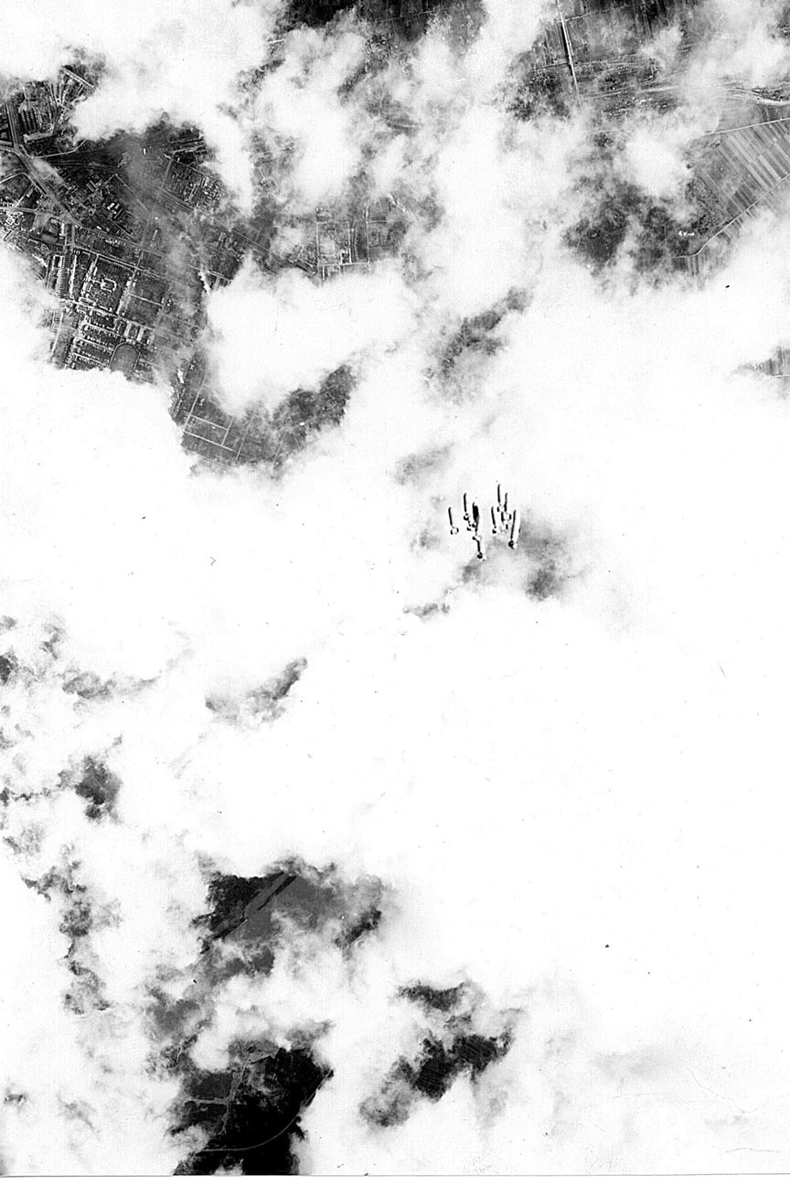
| The above photo was the original orientation of the Unknown Target Photo, now identified as Mannheim. This original photo was rotated 46 degrees clockwise to obtain the north pointing photo at the top of this page. |
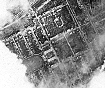
Above is a close-up of a section of the Target photo. Key landmarks are part of a stadium and the square within a square. From a June 10, 2007 Scott Welty e-mail: "The cropping from the Target Photo ... shows the stadium and the buildings forming a rectangle within a rectangle. The inner rectangle turns out to be a courtyard road named Almenplatz." |
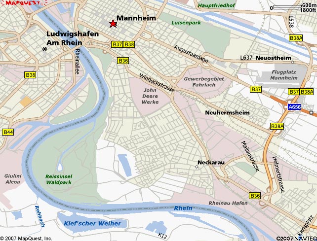
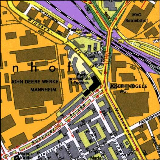
Above is a MapQuest Overview of the Target photo area. Key landmarks are the Kief'scher Weiher, the curved road to the south of it, the John Deere Werke's, and the rail yards area just to the south of Newhermsheim. This map photo provided by Scott Welty from an internet search. From a June 10, 2007 Scott Welty e-mail: "This map shows Mannheim/Ludwigshaven to where the Rhine moves east to west. The railroad yard or depot they are bombing in Photo 1 also shows up in this map. The section of the target photo that solved it all is in the middle of this map. (This was the photo cropping of the stadium and buildings that made a rectangle within a rectangle. See above Section of Target Photo: Stadium and Almenplat. So there was some question whether the stadium area was Mannheim or Neckarau. I've concluded the stadium and distinct buildings are in Mannheim. First, Mannheim is listed as a target city, not Neckarau. Second, the position of the bombs towards the railways suggests Mannheim." |
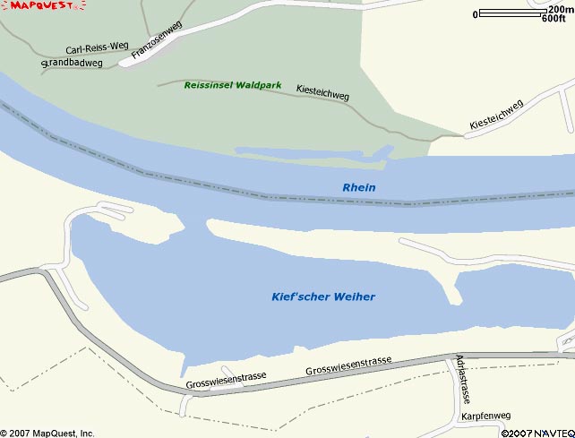
Above is a MapQuest Overview provided by Scott Welty of a section of the Target photo. Key landmarks are the Kief'scher Weiher and the curved road to the southof it. Note the inlet in this photo on the north of the river is in error. This map photo provided by Scott Welty from an internet search. From a June 10, 2007 Scott Welty e-Mail "Attached is a map of the section of the Rhine that appears in Target photo. The Rhine usually flows south/southeast to north/northwest. This part of the Rhine flows east to west. Dave, what you noted might be as a canal system is in MapQuest and Google photos as an inlet and bay, possibly man-made. The curved road you noted can be seen in both MapQuest and Google. Mapquest is, however, INCORRECT in showing a thin pennisula on the North Shore. Both in the Target photo and in Google's current satellite view shows the tip of a shore hugging island and open to water at that end. Mapquest shows it as attached at that end to the mainland." |
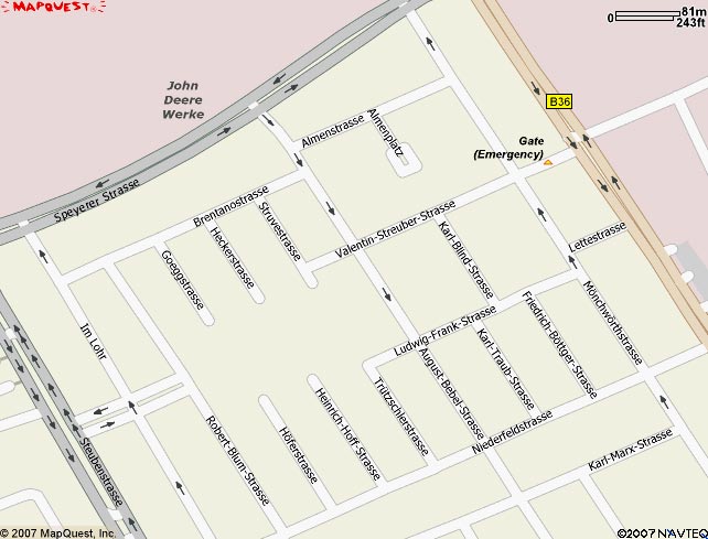
| Above is a MapQuest map of the location of the stadium and the rectangle within a rectangle. This map photo provided by Scott Welty from an internet search. |
| Above is a Mannheim City map of the location of the John Deere Mannhiem works and the rectangle within a rectangle, Almenplatz. This map photo provided by Scott Welty from an internet search. |
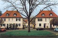
| Above is a ground photo level photo of the courtyard call Almenplatz looking out towards the street. This photo was provided by Scott Welty from an internet search. |